|
|
Post by shellback on Dec 6, 2013 12:38:52 GMT -5
I recently bought the Navionics update card with Sonar Charts. What sonar charts does is let you record a lake with your chart plotter, send the data to navionics, and they make the map for you to download onto your card. Each time you record data on the lake, you can send it in for an update. About a month ago I slow trolled for crappie recording data at the same time. Here's the result with a before and after screen shot with my Humminbird 998C. Keep in mind that areas I didn't actually record, shallower areas, they kinda fudge it in so the depths are not correct. The more recordings sent in, the better the map gets. Check out Navionics site for more info. I hope to get Marsh Creek, Chambers and Blue Marsh next year. 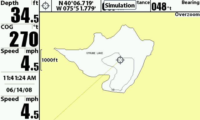 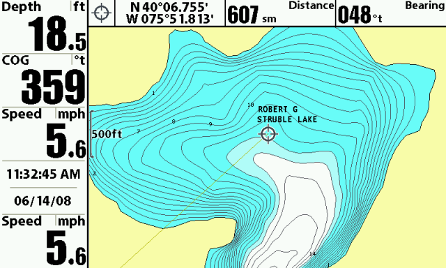 |
|
|
|
Post by bowlerx on Dec 6, 2013 16:26:48 GMT -5
very cool!
|
|
|
|
Post by tomm on Dec 7, 2013 7:48:33 GMT -5
That's a great feature. How'd you get those speeds using electric only?
Tom
|
|
|
|
Post by shellback on Dec 7, 2013 17:39:40 GMT -5
I was running my unit in the simulator mode inside the house. The top picture happened to catch "simulation". It only pops up on the screen every so often. Notice the date shows June of 08 also.
|
|
|
|
Post by tomm on Dec 8, 2013 7:53:46 GMT -5
Ah geeze... I didn't see that. I thought you had a little boat with six or seven trolling motors. LOL
|
|


